State Legislation

Vegetation Management Act 1999

The Vegetation Management Act (VMA) regulates the clearing of vegetation in a way that:

  • conserves sensitive regional ecosystems;
  • ensures the clearing does not cause land degradation;
  • prevents the loss of biodiversity;
  • reduces greenhouse gas emissions; and
  • allows for sustainable land use.

Subordinate legislation:

  • Vegetation Management Regulation 2012.

The Act considers vegetation to be a native tree or plant other than:

  • grass or non-woody herbage; or
  • a mangrove; or
  • a plant within a grassland Regional Ecosystem prescribed under the Vegetation Management Regulation 2012 (i.e., a Schedule 5 Grassland).

Additionally, the Act considers clearing to mean:

  • to remove, cut down, ringbark, push over, poison, or destroy in any way including by burning, flooding or draining; but
  • does not include destroying standing vegetation by stock, or lopping a tree.

Relevance to cropping development:

  • Vegetation clearing should be avoided where possible in the design of a new cropping development.
  • If clearing is unavoidable, developments should target previously cleared areas, classified under the VMA as Category X, or to exempt vegetation mapped as Schedule 5 Grassland. There are no restrictions to development, relating to vegetation clearing, within Category X and Schuelde 5 Grassland areas.
  • New cropping developments unable to avoid clearing of vegetation other than Category X or Schedule 5 Grasslands, may be able to proceed under a legislative assessment process.

Understanding the implications of the Vegetation Management Act for your property

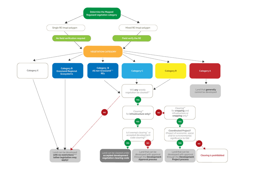
Of the various legislative requirements, compliance with the Vegetation Management Act is generally the most significant consideration. Definitions in the Act as to what constitutes a “tree”, “vegetation”, “clearing” and “Infrastructure” are important in interpreting the Act. Based on the State vegetation mapping and proposed development parameters (dryland, irrigated, etc.) land may be classified with respect to the Vegetation Management Act into the following four categories:

1

Land that can be developed with no restrictions;

This represents land that is mapped as:

  • Regulated Vegetation Category X; or
  • Grassland Regional Ecosystems within Regulated Vegetation Category B; or
  • Regulated Vegetation Category B (other than Grassland Regional Ecosystems), Category C or Category R where woody vegetation is not cleared. (By nature, this is generally only applicable to some drylands cropping).

Note, trees are not considered as “Vegetation” under the Vegetation Management Act when they occur within a Grassland Regional Ecosystem, so may be cleared.

2

Land that can be developed with approval through the Development Approval process;

This represents land that is mapped as:

  • Regulated vegetation Category B (other than a Grassland Regional Ecosystem), Category C or Category R where the clearing is for Fixed Infrastructure (i.e. this excludes centre pivot infrastructure).

By nature, this is only applicable to fixed infrastructure such as fence lines, building sites, irrigation delivery pipelines, etc.).

3

Land that can be developed with approval through a Coordinated Project process;

This represents land that is mapped as:

  • Regulated Vegetation Category B (other than Grassland Regional Ecosystem), Category C or Category R, where clearing is required.

By nature, this is applicable to irrigated agricultural developments where tree clearing is required to construct moving infrastructure such as centre pivots or drylands agriculture where tree clearing is required for cultivated rows).

4

Land that cannot be developed.

This represents land that is mapped as:

  • Mapped as Regulated Vegetation Category A; or
  • Is not approved for agriculture development after evaluation via a coordinated project process.

The Flowchart sets out the above decision processing determining how land is classified under the Vegetation Management Act.

The StoryMap will guide you through the vegetation management mapping process and allow you to navigate to your property and identify which parts of your property as classified into each of the above four categories.

Please note, clarification of the Vegetation Management Act requirements and restrictions is a starting point in determining the regulatory requirements for cropping development. At the scale of the available mapping, this will often point to further investigations required rather than provide a definite answer. In addition, other State, Federal and Local legislation and planning requirements listed below will also need to be taken into account.

VEGETATION MANAGEMENT ACT DECISION TREE

*Vegetation Category can e obtained from:

  1. Free vegetation management report https://www.resources.qld.gov.au/qld/environment/ land/vegetation/vegetation-map-request-form
  2. RVM mapping layers in Globe or QSpatial https://www.resources.qld.gov.au/qld/environment/ land/vegetation/vegetation-map-request-form

If you consider your land to e innncorrectly mapped, a property map of assessable vegetation (PMAV) can be applied for through the Department of Resources
**Note that clearing also includes he death of vegetation due to flooding or other changes to hydrology but does not include lopping where the loping does not kill the tree/shrub.
***Includes Woody grassland REs, Woodlands and Forests
****Check with Local Council to determine if the proposed development constitutes a Materil Change. Development approval maybe required.

Planning Act 2016

This Act establishes a system of land use planning, development assessment, and facilitates the achievement of ecological sustainability.

Integrating:

  • The protection of ecological processes and natural systems;
  • Economic development; and
  • The maintenance of the cultural, economic, physical, and social wellbeing of people and communities.


Subordinate legislation:

  • Planning Regulation 2017.


Relevance to cropping development:

  • Assuming no clearing of any woody vegetation is proposed, and the development is considered accepted development with respect to vegetation clearing (Section 3.1.1), there are other aspects of the cropping development that may require assessment under the Planning Act.
  • If irrigated cropping is under consideration, the following operational works of such a development will require assessment by the Chief Executive:
    o Construction of a dam [Planning Regulation Schedule 8, Table 4, Item 3(f)]
    o Taking or interfering with water [Planning Regulation Schedule 8, Table 4, Item 3(k)]
    o Constructing or raising waterway barrier works [Planning Regulation Schedule 8, Table 4, Item 3(m) OR Planning Regulation Schedule 10, Part 6, Division 4, Subdivision 3]

Water Act 2000

This Act provides a framework for:

  • The sustainable management of Queensland’s water resources;
  • The sustainable and secure water supply and demand management by region;
  • The management of impacts on underground water caused by the exercise of underground water rights by the resource sector; and
  • The effective operation of water authorities.


Subordinate legislation includes:

  • Water Regulation 2016.
  • Water Plan (Cape York) 2019.
  • Water Plan (Gulf) 2007.
  • Water Plan (Mitchell) 2007.


Relevance to cropping development includes:

  • Assuming no clearing of any woody vegetation is proposed;
  • The development is considered accepted development with respect to vegetation clearing, and
  • The intended development proposes the use of irrigation.

Nature Conservation Act 1992

The object of this Act is the conservation of nature, achieved by:

  • Management of protected areas;
  • Protection of native wildlife and its habitat; and
  • Cooperative involvement of landholders.


Subordinate legislation includes:

  • Nature Conservation (Animals) Regulation 2020.
  • Nature Conservation (Plants) Regulation 2020.
  • Nature Conservation (Protected Areas) Regulation 1994.


Relevance to cropping development includes:

  • The Nature Conservation Act provides another layer of regulation on clearing of vegetation aimed at protecting threatened species and their habitats to ensure that development activities are conducted in an ecologically sustainable manner.
  • The Act requires anyone who wishes to clear native vegetation to obtain approval from the Queensland Government. This involves an assessment of the environmental impacts of the proposed clearing and the implementation of measures to mitigate any impacts.

State Development and Public Works Organisation (SDPWO) Act 1971

This is “an Act to provide for State planning and development through a coordinated system of public works organisation, for environmental coordination, and for related purposes.” This Act has the authority under which the Coordinator General declares a Coordinated Project.

Subordinate legislation:

  • State Development and Public Works Organisation Regulation 2020


Relevance to cropping development:

  • If the proposed cropping development requires the clearing of any woody vegetation within a regulated vegetation category (i.e., Category B (excluding Schedule 5 Grasslands), C or R), the development will require approval through the Coordinator General pathway.

Overview of Process

  • An overview of the coordinated approval process is illustrated below
  • The Coordinator General may make one of two types of declarations:
  • Environmental Impact Assessment (EIS): (declared under Section 26(a) of the SDPWO Act). Typically applies to projects that are typically high-risk and/or are large-scale projects that may not be well defined.
  • Impact Assessment Report (IAR) (declared under Section 26(b) of the SDPWO Act). You have Typically applies to projects that are well-defined and low-to-medium risk.

OVERVIEW OF COORDINATED APPROVAL PROCESS

Proponent refers to project to Australian Governnement ( if required )

Pre-lodgement meeting

Application for declaration

Project declared 'coordinated'

Draft terms of reference for EIS prepared*

Final terms of reference issued to proponent

Revised draft EIS/IAR provided (may be publicly notified)

Coordinator-General requests additional information (if required)

Coordinator-General evaluates draft EIS/IAR & pulic submissions

Draft EIS/IAR publicly released^

Proponent prepares draft EIS/IAR

Coordinator-General accepts final EIS/IAR

Coordinator-General releases report on EIS/IAR

Australian Government approval (if required)

Development approvals (eg. material change of use)

* Not applicable for projects requiring an IAR.
^ Public release of an IAR is not required in all circumstances.

Fisheries Act 1994

The main purpose of this Act is to provide for the use, conservation and enhancement of the community’s fisheries resources and fish habitats in a way that seeks to:

  • apply and balance the principles of ecologically sustainable development; and
  • promote ecologically sustainable development.

Subordinate legislation includes:

  • Fisheries (General) Regulation 2019.

Relevance to cropping development includes:

  • Measure to protect aquatic habitats, including rivers, lakes, and coastal waters, which may be impacted by crop development practices such as land use changes, irrigation, and pesticide use.
  • Provisions to protect threatened and endangered species of fish, marine animals, and plants that may be impacted by cropping.

Land Act 1994

The Queensland Land Act 1994 regulates the management and use of land in Queensland based on the principles of:

  • sustainable resource use;
  • land evaluation based on the appraisal of land capability and balancing economic, environmental, cultural and social opportunities and values of the land;
  • allocating land for development in the context of the State’s planning framework;
  • retention of land for the community in a way that protects and facilitates community purpose;
  • protection of environmentally and culturally valuable and sensitive areas and features; and
  • consistent and impartial administrative dealings.

Subordinate legislation includes:

  • Land Regulation 2019
  • Land Title Practice Manual
  • Vegetation Management Regulation 2018
  • Land Sales Act 1984
  • Sustainable Planning Regulation 2009
  • Water Act 2000

Relevance to cropping development includes:

  • sets out the legal framework for land tenure, land use planning, and land development, including agricultural development such as cropping
  • tenure can influence the availability and accessibility of land for cropping development.
  • provides a framework for land use planning, which includes the development of regional plans and land use plans that guide the management and development of land. These plans can influence the type and intensity of cropping development that is allowed in specific areas, as well as the management practices that are required to mitigate any potential environmental impacts.
  • includes provisions for the management of natural resources, including soil and water, which are essential for successful cropping development.

OVERVIEW OF COORDINATED APPROVAL PROCESS

LOOK UP THE LAND TENURE

Does the tenure allow / include agricultural purposes?

Investigate cropping development options

Cropping development cannot be persued

LOOK UP THE LAND TENURE

Does the tenure allow / include agricultural purposes?

Investigate cropping development options

Cropping development cannot be persued

Aboriginal Cultural Heritage Act 2003

The main purpose of this Act is to provide effective recognition, protection and conservation of Aboriginal cultural heritage.

Subordinate legislation includes:

  • Aboriginal Cultural Heritage Regulation 2018.
  • Aboriginal Cultural Heritage Guidelines 2021.
  • Aboriginal and Torres Strait Islander Cultural Heritage Duty of Care Guidelines 2015.
  • Aboriginal Cultural Heritage Code of Practice 2018.
  • Aboriginal Cultural Heritage Duty of Care Handbook 2010.


Relevance to cropping development includes:

  • Requirement for the identification and registration of cultural heritage places and objects, and the development of management plans for places, objects and areas of land that have traditional significance to Aboriginal people, which may be impacted by cropping development.
  • process for consultation and engagement with Aboriginal people to ensure that their cultural heritage is appropriately recognized and protected.
  • requirement to conduct cultural heritage assessments and obtain the appropriate approvals before conducting any activities that may impact on Aboriginal cultural heritage.